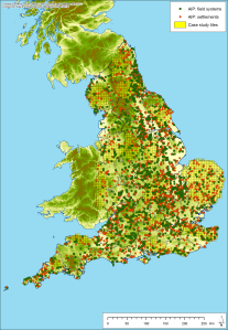
The Archaeological Investigations Project (AIP) is an ongoing project at the University of Bournemouth that collates the brief results of commercial archaeological investigations in England for each year. With the very kind assistance of their Ehren Milner, we have extracted data from their database for our period in respect of two specific classes of monument type: settlements and field systems. These two search queries were selected first as they seemed to me to be two of the key monument types of interest to our project: we will most probably ask Ehren to undertake further, different or revised queries in addition in the future.
The search terms used were taken from the English Heritage thesaurus, as that is used by many organisations and it seemed a sensible starting point. Terms were selected from the list where they were relevant to our period of interest (e.g. we did not include terms under the settlement class like ‘Olympic village’ or ‘railway workers temporary settlement’), leaving out some longer terms which ought to be captured by a subset of their content (e.g. by including ‘field system’, we also ought to catch items named ‘Celtic field system’, ‘coaxial field system’, ‘enclosed field system’, etc.).
The field system query term list was:
CULTIVATION MARKS
ASSART
CORD RIG
LYNCHET
STRIP LYNCHET
PLOUGH MARKS
ARD MARKS
RIDGE AND FURROW
FIELD
PADDOCK
PASTURE
PLOUGH HEADLAND
STRIP FIELD
FIELD SYSTEM
OPEN FIELD
The settlement query term list was:
SETTLEMENT
BURGH
CRANNOG
BURH
ENCLOSURE
OPPIDUM
HILLFORT
FORT
CLIFF CASTLE
ROUND
HAMLET
HOMESTEAD
LAKE VILLAGE
TOWN
CANABAE LEGIONIS
CIVITAS CAPITAL
COLONIA
MUNICIPIUM
VICUS
VILL
VILLAGE
It is not claimed that these lists are exhaustive or likely to capture every instance of these two classes of monument. For instance, under settlement I was uncertain whether I should have included ‘villa’ or not, especially as I did include terms like ‘enclosure’ and ‘fort’. The searches would also not capture objects recorded using any different terminologies, or sites of too small a size to be recorded within monument types of this sort of scale (e.g. an intervention which only discovered one ditch of a field system or settlement could not properly be recorded as such by the excavator without further supportive evidence, so would likely be recorded in the AIP as simply ‘ditch’).
In any event, subject to these caveats, the data received from Ehren (in .mdb database format) was exported to a .csv table and processed using a Python script to convert the OS NGRs (see my previous post) to numeric x and y coordinates (only 3 sites of over 4,000 seemed to have incorrectly recorded NGRs, i.e. they had an odd number of digits) and to extract the periods recorded for each site to a separate field in the new output table. This processed table can then be imported into ArcGIS in the conventional fashion.
Here is a map of the results, plotted against our initial proposed case study locations:

This data is especially useful as it helps to fill gaps between areas where the National Mapping Programme (NMP) has not yet been undertaken. For example, Cambridgeshire has had much commercial archaeology done in recent years, but has not been surveyed by the NMP as yet. Hopefully, by using data from the HERs, EH data, PAS data, and AIP data in combination (alongside other more specific datasets), we ought to be able to build up an excellent picture of English archaeology for our period.
Chris Green

2 thoughts on “The AIP: maximising the picture”