
Ever since I was an undergraduate (and attempted to write a “mental geography” of Roman Britain for my dissertation), I have been interested in Claudius Ptolemy’s Geography. Ptolemy was an Alexandrian Greek and his Geography dates to the mid second century AD: it contains coordinates from which it is possible to make maps of the entire known world at that time, including data representing the earliest surviving reasonably accurate survey of the British Isles. For the purposes of the EngLaId Atlas, that I am currently working on, I decided to see if I could plot Ptolemy’s Britain (or Albion as he called it) over the modern OS map.
To do so, I copied out the coordinates for Ptolemy’s places (representing points along coastlines, islands, and major settlements) from Rivet & Smith 1979. I suspect that there may be one or two typos in their lists (as a couple of the points in the final maps are not quite in the same place as they are on Rivet & Smith’s map), but I am not too worried about that for now. The task was then to convert Ptolemy’s coordinates so that they could be plotted onto the OS National Grid.
The first job was to correct for Ptolemy’s underestimate of the circumference of the planet (it was this underestimate that caused Columbus to be so confident about being able to reach the Indies by sailing west, thus accidentally discovering the Americas): to do so, all of the coordinates were first multiplied by 0.798. I then needed to recentre the coordinates so that they related to modern latitude / longitude: I used London / Londinium as a fixed point in both Ptolemy and the modern world, on the assumption that the provincial capital of Britannia ought to be relatively precisely located in Ptolemy’s data. This involved adding 8.41 degrees to each latitude measure and subtracting 16.06 degrees from each longitude measure.
I then created a shapefile in ArcGIS from the coordinate list using the WGS84 projection settings and then reprojected the map into OSGB 1936, ArcGIS’s representation of the OS National Grid. The points were then filtered out into islands, settlements, and coastline vertices. I had given the coastline points an “order” field (based upon the order of coordinates in Ptolemy) and used the Points to Line tool in ArcGIS to convert them to a line. I then converted the line to a polygon using Feature to Polygon. Finally, a few extra vertices were added to the coastline polygon using the editing tools in order to ensure that the settlement points were all on dry land. Here is the result:
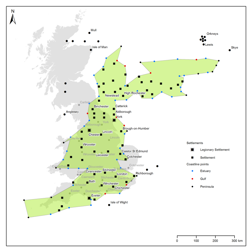
Several things jump out. The most noticeable (and long commented on) is Ptolemy’s rotation of Scotland. Why he did this has been the subject of much debate, possibly being due to him believing that a N-S Scotland would extend too far north or possibly being due to a lack of reliable data on travel times through those non-Imperial lands. The latter is rather key to understanding the Geography: whereas latitude was fairly straightforward to calculate in the past, without chronometers longitude was much more difficult and relied largely upon calculations made using travel time itineraries. We can see the results of this in the way that most of the settlements in England / Wales are reasonably precise in their latitude (N-S) but much more imprecise in their longitude (E-W): York forms a good example. Overall, considering the time when it was constructed, Ptolemy’s Geography contains an impressive representation of Britain (south of Scotland).
I then experimented with a couple of transformations to see if I could improve the plotting onto the National Grid. First, I tried rotating the data so that the north of England more closely aligned with the modern map (actually an affine transformation using London, York and Chester as fixed points, so the geometry is slightly deformed, especially for Scotland):
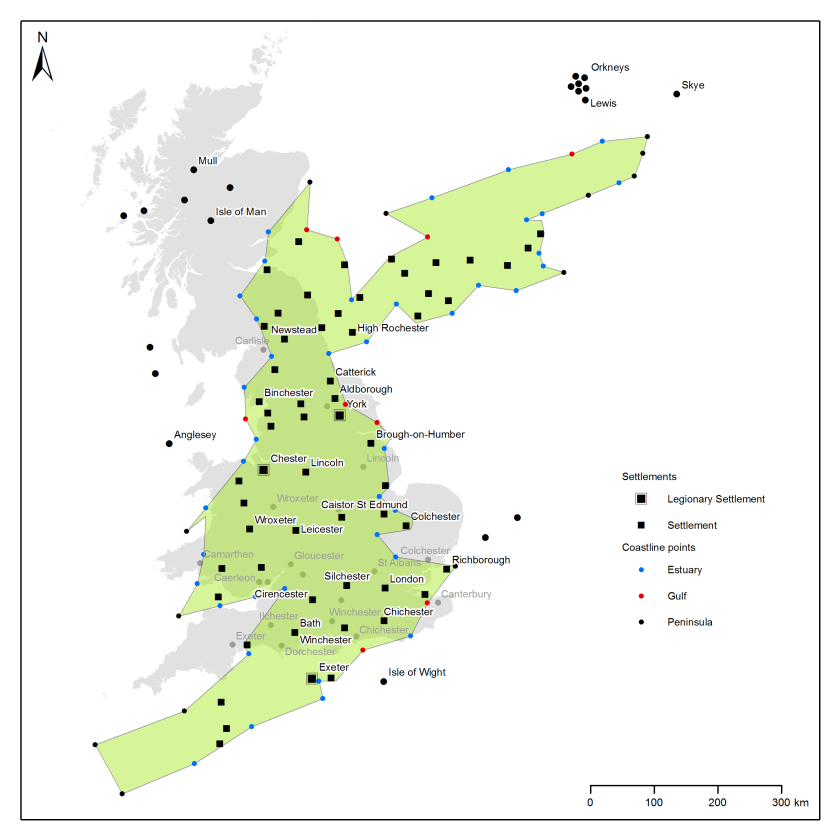
The result is not really all that great, as the south of England then becomes much less closely aligned with the modern map. I also tried a rubbersheet transformation, using London as a fixed point and moving Ptolemy’s York onto modern York:
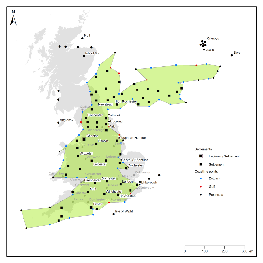
This turns the map into a really quite close approximation of the modern English / Welsh coastline, with the exceptions of the immense length of the south west and the rather stunted East Anglia. However, as it disturbs the geometrical relationship between Ptolemy’s coordinates, I decided in the end that my first model was probably the best: after all, I could keep adding points to the transformation until everything mapped perfectly onto the modern geography, but what would be the point of that? I would just be recreating the OS map.
This was just a short experiment for the purposes of debate and making a nice map. It seems likely that I may have done something spatially naive in plotting the data using the WGS84 settings, but the end results are rather pleasing in any event.
Chris Green
References
Rivet, A.L.F. & C. Smith. 1979 The Place-names of Roman Britain. London: Batsford.
The maps contain Ordnance Survey data (OpenData). (C) Crown Copyright and Database Right 2016.
