Further to my previous post on mapping broad-brush pottery distributions, I was reasonably content with the maps for prehistory and the Roman period (albeit that they had significant shortcomings in terms of temporal currency), but I was not really satisfied with the amount of data I could find for the early medieval period. One particular shortcoming was the lack of data for the earlier half of the period, for which I had been able to discover very little.
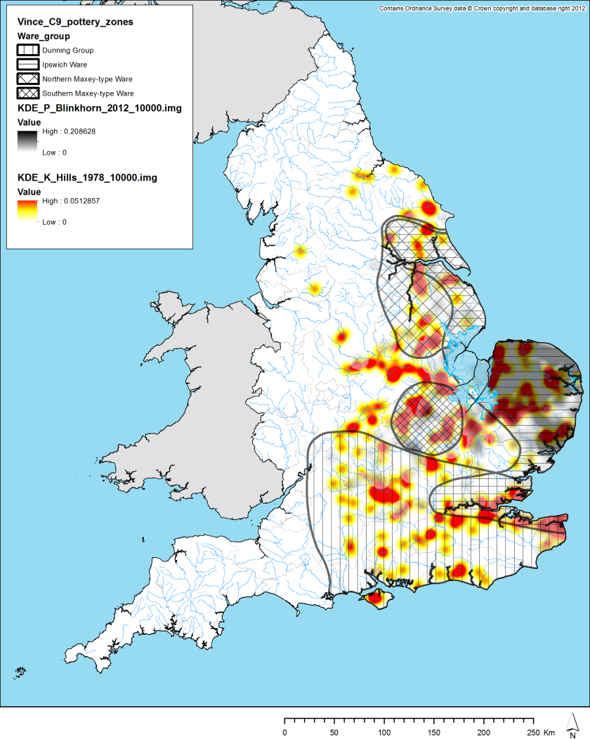
After my blogpost, Helena Hamerow found a map in a publication by Catherine Hills which included a map of earlier Anglo-Saxon pottery. A little bit more investigation showed that this was adapted from Myres 1969 (Map 1). As such, it is clearly a very old source, with no evidence included from the massive post-1990 explosion in developer-funded archaeology, but it seems to remain the most complete national map for the period. I therefore digitised the dots in this map and the Blinkhorn (2012) map referenced previously and turned them into density surfaces. With this simple task complete, it felt like my picture was becoming more useful:

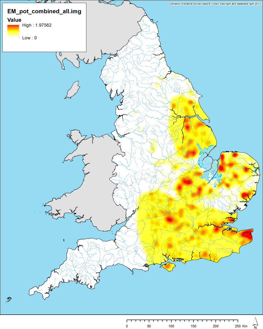
However, the fact that the Myres data is quite so out-of-date suggested we ought to find some more modern proxy for the ceramic evidence. Letty suggested we ask Toby Martin, a British Academy postdoc here at the Institute, if we could use his corpus (2011) of Anglo-Saxon furnished graves (C5th to C6th) as just such a proxy, insofar as she felt that the people buried in such a fashion should also be people who use pottery. Toby was happy to oblige and so I created a model using a density plot of his data in addition to the previously mentioned three sources. Because Toby’s material is not actually ceramics but just being used as a proxy, I gave his data a lower weighting in the model. I did the same for Vince (1993) as his zones are rather too vague in extent for my purposes here. So, essentially, all of the four sources were normalised by their maximum value (so that they varied between 0 and 1), and then combined as follows (in two steps, so I could separate out earlier and later):
(Myres + 0.5 Martin) + (Blinkhorn + 0.5 Vince)

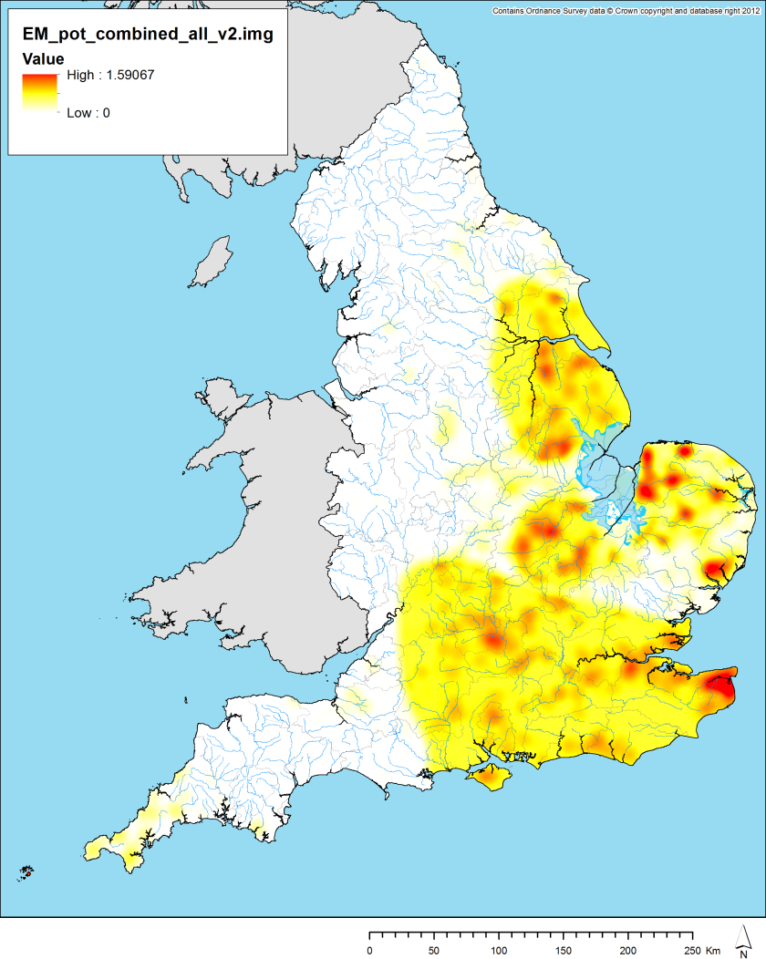
However, there is one very clear problem with this model and that is that all of the sources used are explicitly “Anglo-Saxon”. In other words, where are the “Britons”? Toby and I did a bit of investigating and found a very interesting PhD thesis by Imogen Wood (2011) which included three maps of Cornish pottery of the early medieval period. This was exactly what I needed to help colour at least one of the none “Anglo-Saxon” parts of the map. Rather nicely, Wood’s first map was largely temporally coincident with Myres and Martin and her second map largely temporally coincident with Blinkhorn and Vince. So, I simply expanded the model as follows (again split into two stages):
(Myres + 0.5 Martin + Wood_early) + (Blinkhorn + 0.5 Vince + Wood_late)

The final model is shown above. I also have a couple of maps which split this out into the earlier (C5th-6/7th) and later (C7/8th-9th) parts of the early medieval period, but I feel that the combined model is probably the most robust. Although some of the input data is not perfect due to its age (Myres) or its spatial vagueness (Vince), I feel that is probably the best model we can currently construct for broad brush early medieval pottery presence / absence, at least without putting in substantially more work.
Any thoughts or disagreements are more than welcome, however!
Chris Green
References
Blinkhorn, P. 2012. The Ipswich Ware Project: Ceramics, Trade and Society in Middle Saxon England. Medieval Pottery Research Group Occasional papers.
Martin, Toby F. 2011. Identity and the cruciform brooch in early Anglo-Saxon England: an investigation of style, mortuary context, and use. Unpublished PhD thesis, University of Sheffield.
Myres, J.N.L. 1969. Anglo-Saxon pottery and the settlement of England. Oxford: Clarendon Press.
Vince, A. 1993. “Forms, Functions and Manufacturing Techniques of Late Ninth- and Tenth- Century Wheelthrown Pottery in England and their Origins.” In D. Piton (ed.), Travaux du Groupe de Recherches et D’Etudes sur la Céramique dans le Nord – Pas-de-Calais; Actes du Collque D’Outreau (10 -12 Avril 1992). Numéro hors-série de Nord-Ouest Archéologie, pp.151-64.
Wood, Imogen. 2011. Changing the fabric of life in post-Roman and early medieval Cornwall: an investigation into social change through petrographic analysis. Unpublished PhD thesis: University of Exeter.

Very interesting, and good to see my old dataset put to some use!
Thanks for all your help on this, Toby.
Dear Chris Green, please could you let me know more details of the map of pottery which you say I have published., based on “Myers” . As far as I know If I ever published a map based on the Corpus of Anglo-Saxon pottery assembled by J N L Myres in 1977 it was so long ago I have forgotten it, or this was just a sketch for a lecture. The nearest I have come to doing this in recent years has been adapting maps of cremation cemeteries, with no claim to completeness, just to illustrate the geographical focus of cremation. Im not aware of attempting to publish a map of A-S pottery recently and suspect it would not be an easy task.
Using Toby’s data as a proxy for pottery has the drawback that many of his finds come from inhumations, whereas cremations produce far more of the complete pots used by Myres. There is regional and chronological distinction between the two rites and thus your map is more likely to show inhumations than pottery. Of course much pottery also comes from settlement sites which do not have the same bias, but usually include few decorated sherds.
Hi Catherine,
Glad to hear from you. The map came into my hands originally from a German language paper of yours from 1978, which Helena Hamerow gave me a photocopy of the map from. This is the reference:
Hills C.M.(1978). Sachsische und Angelsachsische Keramik, J. Ypey and C. Ahrens (eds.), Sachsen und Angelsachsen, Vol.32 (Veroffentlichungen des Helms-Museums.) Hamburg: Helms-Museums. 135-142.
As I said in the post above, we found another version of the same map in Myers 1969, so I assume you sourced it from there (or another Myers publication) at the time. I haven’t seen any map based on later work by Myers.
In any event, I don’t doubt for a second that using funerary evidence as a proxy is imperfect, but as you say, it would not be an easy task to create a modern corpus of early med / A-S pottery. Doing so is certainly beyond the scope of this project, so proxies and older data are the best I can currently do, unfortunately. I have little doubt that the task of creating an updated corpus would be a very useful task, however.
Chris
Dear Chris, thanks, I do know that paper, even still have offprints of it, glad there isn’t a more recent paper I have forgotten . In 1978 using MYRES (NB sp) was most authoritative source. To get an accurate map now you would have to search the grey literature in the ADS which would be a significant research enterprise- interesting but time consuming. This would produce more pottery from settlement sites which would make it possible to compare early Saxon with middle and later- currently early A-S maps, mostly indeed still derived from Myres, largely map funerary activity whereas the mid-late AS map settlements, so it is a different kind of evidence, not straightforwardly comparable. The main settlement sites i.e. Mucking, West Stow and West Heslerton do have a reasonable amount of pottery, not much of it decorated, mostly from grubenhauser (SFBs) , another biassing factor- sites with few SFBS like Chalton or Yeavering don’t produce much pottery.
The lack of recovered pottery in western Britain is usually interpreted as evidence of actual lack of pottery, there really isn’t any western material to set against the eastern, except for the imports from the Mediterranean or Gaul- see Ewan Campbell 2007on this. Interesting there is some Cornish pottery, since that is where the imports cluster. Alan Vince was reported as saying even west Midlands were aceramic till 12th century. Pottery not as essential as archaeologists sometimes seem to think: wooden bowls and plates, “treen” in common use till end of Middle Ages- not often preserved, an old greasy bowl would have been good fuel for the fire.
Hi Catherine,
Thanks for the further reply. Oops re. the spelling error on Myres, I’ll correct it! I don’t doubt for a second that pottery is over-emphasised in archaeological interpretation due to its (generally) good durability (compared to many materials at least). Of course, its other great usage is as a cheap source of dating evidence, which is kind of the angle I was aiming at here. Essentially, the idea was to map areas that were more or less ceramic / aceramic to see if that had an effect on the precision of dating of sites. This is definitely an issue in Iron Age and (to a lesser extent) Roman archaeology, and I suspect also one in the early medieval period: western England is also seemingly much less “ceramicised” in earlier periods.
The Cornish pottery included in my model came from the thesis by Imogen Wood referenced in the main post. I suspect this has a tendency to sometimes get overlooked as it is a “British” rather than an “Anglo-Saxon” area, perhaps? Or maybe I am being too cynical there.
In any event, the point you make about the difficulty of comparing burial and settlement evidence is valid and makes any interpretation complicated. It does seem reasonable to assume that people leaving pottery in graves must have been using pottery in their daily life, although the opposite clearly does not apply (i.e. aceramic graves do not imply aceramic daily life). As such, although the detail of the early / late comparison does not bear intense scrutiny, the overall pattern of high / low usage of pottery within a period or sub-period ought to have some validity to it. Or so I hope!
Thanks for your thoughts and comments!
Chris
Sorry Im not usually a blog follower, so not replying very quickly. Re Imogen Wood- its true I don’t know this thesis and should read it, and also true there is an east/west divide in early medieval studies in Britain. But most of the literature from scholars based in the west (e.g. Campbell as above, Steven Driscoll, Nancy Edwards) confirms the scarcity of local pottery.
Re pottery in burials: there is some problem here as the cremation pottery has been selected for its decoration, form and size, possibly deliberately made for that purpose, so it is part of funerary practice rather than a simple reflection of pottery usage. But the sites where we have both settlement and cemetery, Mucking and West Heslerton, do have broadly comparable pottery though far less decoration in settlement than graves, so might not be wholly non comparable- possibly in relate not inhumations though rather than cremations.
Thanks Catherine. Sorry for the slow reply in turn, I’ve been away on holiday.
I suppose my argument would be that although funerary-context and settlement-context pottery have different forms and associations, the presence of pottery in the funerary context at least indicates that people in the past were aware of the technology and, as such, it does not seem likely they would ignore its potential usefulness in daily life. Unless it was subject to some sort of taboo. It’s all a little murky interpretatively, but we’re mostly interested in mapping presence / absence, so I think the funerary evidence can at least stand for that. Or so I would argue!